Officials assisting residents with finding new housing
Blogmaster's Note - At Missouri River Relief's 2010 river clean-up in St. Joseph, we delivered a bunch of trash bags to the extremely nice folks living at St. Joseph's Tent City, right on the banks of the river by the old railroad bridge. They filled those bags with trash and asked for more. This is another bit of sad news.
Originally published by St. Joseph News-Press on March 26, 2011
Click here for original link
by Kim Norvell
Kenneth Paxton, who has lived on the river adjacent to Tent City for more than a year, was busy cleaning up some of the trash left in another encampment Friday afternoon. Mr. Paxton will soon be leaving his own tent as have all but two other Tent City residents. The Social Security Administration will pay for a motel room, Mr. Paxton says, until permanent housing can be found.
The official answer as to who owns the territory inhabited by homeless men and women remains unclear. However, the process of finding permanent housing for Tent City residents has been expedited, because the Union Pacific railroad believes the land belongs to them.
Monday, March 28, 2011
Concerns raised about Missouri River Reactors
Concern is in reactors’ design
Originally published on March 27, 2011 by Omaha World-Herald
Click here for original link
By Nancy Gaarder
Midlanders don’t have to look far to find the type of nuclear reactors that are in crisis in Japan.
Nebraska and Iowa each has one similar to the Japanese reactors that released significant radiation after being damaged by an earthquake and tsunami.
Are the Midlands’ reactors — Nebraska’s largest and Iowa’s only one — vulnerable to similar releases during an extraordinary crisis?
The two Midlands reactors that rely on the design in question are Cooper Nuclear Station and Duane Arnold Energy Center.
Sunday, March 27, 2011
Weekend river cleanup nets everything and kitchen sink
Here's a few links of news stories about the Confluence Trash Bash on Saturday, March 26. The massive urban cleanup was organized by Confluence Partnership, St. Louis Metropolitan Sewer District, St. Louis Audubon and a long list of partners. Missouri River Relief took 32 volunteers out on the Missouri River to clean-up two sites. One of these sites was an abandoned farm dump on the Cora Island Unit of the Big Muddy National Fish & Wildlife Refuge. We've been working on cleaning up that site for three years.
Here's a link to the Fox Channel 2 story on the cleanup
The St. Louis Post Dispatch published this following story on March 27, 2011.
Click here for original link
by Blythe Berhard
Volunteers picked up everything and the kitchen sink at the annual Confluence Trash Bash river cleanup Saturday at Old Chain of Rocks Bridge.
Ben Duncan, 10, won the prize for weirdest article of trash for spotting a ceramic sink in the bushes off Hall Street near the Mississippi riverfront in north St. Louis.
The fourth-grader came with his Cub Scout pack to get dirty and collect junk. The boys scaled their hill of garbage bags and discarded tires to pose for pictures before public works staffers hauled it away.
"It's fun because we do stuff that guys like us like to do," Ben said.
Yankton’s ‘Great Flood’
130th Anniversary Of Flood Highlights Threat River Once Posed
Originally published in Yankton Press Dakotan on March 26, 2011.
Click here for original link.
by Nathan Johnson
As the waters of the Missouri River rose, dozens of people could be seen clinging to the steep roof of John Nelson’s brick house.
Hours earlier, the residents of Green Island had been singing a Psalm led by the Rev. Charles Seccombe, hoping that the rising water would recede. But it had not.
Despite the fact that Nelson’s house sat on high ground, the villagers found themselves being forced to the attic and then through a window onto the roof.
Fortunately, rescuers arrived by boat to take the frightened individuals to safety and avoid any fatalities.
The scene played out 130 years ago this weekend, during what became known as the Great Flood of 1881. While the extent of its devastation has been exaggerated in some accounts, there is no doubt it was a tremendous event that changed the course of local history.
S.D. hasn't seen a flood like 1881
Vermillion moved to higher ground after the deluge
Originally published on March 22, 2011 in the Sioux Falls Argus Leader
Click here for original link.
by Jill Callison
Blogmaster's note: This article published on the 130th anniversary of this massive ice gorge flood of Vermillion and Yankton. It doesn't note that the reason such a flood is unlikely these days (other than the fact people moved out of the floodplain) is that the Gavin's Point Dam was built not far upstream, completed in 1957. The resilience of these communities is inspiring.
In its March 24, 1881, edition, the Dakota Republican noted that the Missouri River had risen 6 feet during the week but had not flooded.
A few days later, the newspaper's office in Vermillion was gone, swept away by a flood. The Dakota Republican would not print again until July 1, 1881.
That came after Vermillion residents had voted to move the town of more than 600 residents to higher ground, Vermillion historian Tom Thaden says.
"The original site was right next to the Missouri," he says. "Now we're pretty much in the same area, just on the bluff rather than below it."
Thursday, March 24, 2011
Opinion Editorial: More than just a few things have changed since 1944
Blogmaster's note: this is an editorial published in the Bismark Tribune about the MRAP study. Click here for more on MRAPS. Click here for other locations of public meetings and a link to download the draft scoping summary.
Originally published on March 24, 2011, in the Bismark Tribune
Click here for original link
by Brian Gehring
A few weeks ago the Army Corps of Engineers released its draft scoping summary report on the Missouri River management known as MRAPS.
It stands for Missouri River Authorized Purposes Study. The study got it beginning back a couple years ago when Sen. Byron Dorgan called for a review of how the river system was managed.
That management study was based on a document adopted in 1944 when the dams were built along the river.
Dorgan said it when he led the push to have Congress study how the river has been managed: things have changed since 1944.
The MRAPS draft study, all 340-some pages, is available online at www.mraps.org. For those who do not have Internet, the draft study is available at the Bismarck Public Library through April 30.
The draft is the culmination of public meetings that the corps hosted up and down the river last summer, giving the public and various state and tribal representatives the opportunity to comment.
There is another set of meetings scheduled to allow the public and others another chance to comment.
That meeting is coming up Tuesday at the Doublewood Inn. The format of the meeting is same with a presentation from the corps from 5 to 6 p.m. and then public comment afterward.
Things have changed along the river in 60-some years but it’s not just the river. Usage has changed on our two reservoirs that are a part of the system.
The eight original authorized purposes are flood control, hydropower, water supply, irrigation, navigation, recreation, water quality and fish and wildlife.
Water quality, irrigation and hydropower are still top issues as far as North Dakota is concerned. The same goes for water quality, recreation and fish and wildlife.
The area that has been questioned over the years is that of navigation. Little or no navigation of consequence happens downstream.
When dollars are compared to what the water generates from fishing and recreation and navigation, you would think one would have a difficult time arguing in favor of navigation and managing the river for that purpose.
We have water back in our reservoirs now but the thing with people’s memories is they can be short when times are good.
We don’t mind sharing our water when the need is there and justified. And, we don’t mind holding the water back when, as has been the case in recent years, there is too much of it downstream in the spring.
We just don’t want to be charged for storing water that is ours.
And when you think about it, the Missouri River, post-dam era, is still in its infancy when it comes to a river.
Sixty-some years is a mere drop in the bucket comparatively speaking when talking about the age of a river.
We are still learning a lot about how management practices are affecting the overall health of the river system and those who derive benefits from, and often rely on the river for survival.
We have seen how fish like pallid sturgeon and paddlefish and shore birds like terns and plovers have been negatively affected.
They are the first species to give an indication something may not be right. It takes us humans a bit longer to come around most times.
A lot has changed since 1944. And now we are in the position to be there as it changes and hopefully do something positive as it is happening.
If you have a stake or an interest in the river, this is one of those issues or causes, call it what you will, to become involved in. Or, at the very least, become informed about what is on the line.
Birds rest, feed at DeSoto National Wildlife Refuge
Originally published on March 23, 2011 in the Omaha World Herald
Click here for original link
by Mike Brownlee
MISSOURI VALLEY, Iowa — Waterfowl and other migratory birds are making a brief stop on the 7,500 acres of wetlands, forest, lakes and ponds at DeSoto National Wildlife Refuge on the Missouri River north of Omaha.
“The Missouri River valley, historically, has been a migration corridor,” said Tom Cox, refuge manager. “I liken it to a family vacation trip. And we're like a hotel and restaurant for migration.
“We provide an area for them to rest and replenish fat reserves. So when they hit their nesting spot up north they're ready for breeding. They need to be healthy for breeding and hatching.”
Bald eagles usually migrate along with the geese, feasting on the frail, and Cox said many have been seen on the refuge.
The waterfowl northern migration season began toward the end of February, Cox said, and ends in early April. During the peak days in early March, there were about 50,000 ducks and geese at the refuge.
Click here for original link
by Mike Brownlee
| photo - Mike Davis, Omaha World Herald |
“The Missouri River valley, historically, has been a migration corridor,” said Tom Cox, refuge manager. “I liken it to a family vacation trip. And we're like a hotel and restaurant for migration.
“We provide an area for them to rest and replenish fat reserves. So when they hit their nesting spot up north they're ready for breeding. They need to be healthy for breeding and hatching.”
Bald eagles usually migrate along with the geese, feasting on the frail, and Cox said many have been seen on the refuge.
The waterfowl northern migration season began toward the end of February, Cox said, and ends in early April. During the peak days in early March, there were about 50,000 ducks and geese at the refuge.
Wednesday, March 23, 2011
Missouri River shipping season starts
blogmaster's note: First barge transit of the season! The Mary Lynn hits the river today for a fertilizer haul to Brunswick Terminal. The Mary Lynn is a really cool, sleek towboat designed with a shallow draft for the Missouri River.
Originally Published in St. Louis Business Journal on March 22, 2011
Click here for original link.
AGRIServices is starting its shipping season early, with eight barges of fertilizer set to leave St. Louis on Wednesday and arrive Sunday in Brunswick, in Chariton County in north-central Missouri.
The shipping season officially begins April 1, when the U.S. Coast Guard places navigational buoys on the river.
But “the water levels are good enough to get our shipping season started early, and we expect to be busy through mid-December,” said Kevin Holcer of Brunswick-based AGRIServices, in a statement. “We expect to increase our shipping efforts by up to 15 percent.”
AGRIServices will start pushing more than 9,000 tons of fertilizer up the Missouri River on Wednesday via the M/V Mary Lynn, a 3800-horsepower shallow draft boat.
The Missouri Department of Transportation, which supports waterways shipping on the Missouri River, said Jefferson City’s River Terminal expects to receive 6,000 tons of cement Tuesday, and that Hermann Sand and Gravel plans to start moving freight later this week.
"Our goal is to increase the freight moved on the Missouri River, increase connections to other transportation modes, and provide economic development opportunities along the river corridor,” Ernie Perry, freight development administrator for MoDOT, said in a statement.
MoDOT said expectations are for the biggest shipping season on the Missouri River in a decade. In 2010, about 334,000 tons of goods, or the equivalent of 13,000 tractor-truck loads, was shipped on the Missouri River, a 24 percent increase compared with 2009, according to MoDOT.
Perry said one barge carries the same amount of cargo as 70 semi-trucks or 16 rail cars.
Cleanup group goes to the air to map Missouri River trash
blogmaster's note: For more info on this effort, click here: http://www.riverrelief.org/updates/entry/river-relief-conducts-aerial-trash-scout/. As we post photos and maps from the scout, you'll be able to access from that page.
Originally published in the St. Louis Post-Dispatch on March 23, 2011
Click here for original post
by Mark Schlinkmann
To prepare for its 10th annual Missouri River cleanup later this year, an environmental group recently launched its first aerial mapping survey of most of the 380 miles of the river from Kansas City to St. Louis.
"We saw a lot of trash accumulation we were not able to see" in past surveys by boat, said Jeff Barrow, director of Columbia, Mo.-based Missouri River Relief. "The photos will give us a plan on how to approach it."
 There weren't many surprises in the St. Louis area, he said. One exception was a heap of junk near Howell Island west of the Daniel Boone Bridge that carries Highway 40 between St. Louis and St. Charles counties. That area will be targeted during the cleanup.
The overhead views are of particular help in finding large accumulations of debris that wash into nearby woodlands during flooding and stay when the water recedes, he said. Much of that was found in low-population areas in western Missouri, such as near the mouth of the Grand River near Brunswick.
"There must have been 10 acres of driftwood and trash, including refrigerators and 55-gallon drums," said Barrow, who took part in the survey.
He said various riverside dump sites obscured by vegetation also were pinpointed, including one near New Haven in Franklin County.
The survey was conducted March 11-12 with GPS-synchronized cameras in a six-seat Cessna run by Colorado-based EcoFlight, which does aerial scouting for various environmental causes.
This year's cleanup campaign, called the Big Muddy Clean Sweep, has another twist.
For the first time, the organization has chartered a barge to cruise the length of the river and serve as the common receptacle for trash picked up in various drives along the way.
The trash will then be taken to a terminal for transfer to landfills or recycled. In the past, trash from each local drive was disposed of separately.
"This will be a lot more efficient," Barrow said.
He added that "it makes a powerful visual statement when people see that barge with a mountain of trash."
This year's effort begins Sept. 10 in Kansas City. Three of the stops and local cleanups will be in the St. Louis area — at Washington, Mo., Oct. 15, St. Charles on Oct. 22 and around the confluence with the Mississippi River on Oct. 29.
The confluence area also will be the subject of a trash collection campaign this Saturday overseen by another group, the Confluence Partnership, and involving Missouri River Relief and other organizations. That event is called the Confluence Trash Bash. For more information, go to confluencegreenway.org.
Originally published in the St. Louis Post-Dispatch on March 23, 2011
Click here for original post
by Mark Schlinkmann
To prepare for its 10th annual Missouri River cleanup later this year, an environmental group recently launched its first aerial mapping survey of most of the 380 miles of the river from Kansas City to St. Louis.
"We saw a lot of trash accumulation we were not able to see" in past surveys by boat, said Jeff Barrow, director of Columbia, Mo.-based Missouri River Relief. "The photos will give us a plan on how to approach it."
The overhead views are of particular help in finding large accumulations of debris that wash into nearby woodlands during flooding and stay when the water recedes, he said. Much of that was found in low-population areas in western Missouri, such as near the mouth of the Grand River near Brunswick.
"There must have been 10 acres of driftwood and trash, including refrigerators and 55-gallon drums," said Barrow, who took part in the survey.
He said various riverside dump sites obscured by vegetation also were pinpointed, including one near New Haven in Franklin County.
The survey was conducted March 11-12 with GPS-synchronized cameras in a six-seat Cessna run by Colorado-based EcoFlight, which does aerial scouting for various environmental causes.
This year's cleanup campaign, called the Big Muddy Clean Sweep, has another twist.
For the first time, the organization has chartered a barge to cruise the length of the river and serve as the common receptacle for trash picked up in various drives along the way.
The trash will then be taken to a terminal for transfer to landfills or recycled. In the past, trash from each local drive was disposed of separately.
"This will be a lot more efficient," Barrow said.
He added that "it makes a powerful visual statement when people see that barge with a mountain of trash."
This year's effort begins Sept. 10 in Kansas City. Three of the stops and local cleanups will be in the St. Louis area — at Washington, Mo., Oct. 15, St. Charles on Oct. 22 and around the confluence with the Mississippi River on Oct. 29.
The confluence area also will be the subject of a trash collection campaign this Saturday overseen by another group, the Confluence Partnership, and involving Missouri River Relief and other organizations. That event is called the Confluence Trash Bash. For more information, go to confluencegreenway.org.
North Dakota: Legislature Urges Army Corps of Engineers to Give the State Back Water Control
Originally published in PlainsDaily.com on March 22, 2011
Click here for original link
By Kate Bommarito
The Senate passed HCR 3019 today, a resolution urging the Army Corps of Engineers (COE) “to immediately cease wrongful denial of access and wrongful requirement of payment for the natural flows of the Missouri River,” and demands that the COE “forgo any attempt to charge water users in North Dakota a fee to use water from Lake Sakakawea or Lake Oahe.”
Both the Governor and the Attorney General had testified at the resolution’s committee hearing. At the House hearing, Dalrymple called the US Army Corps of Engineers’ new policies both “unjustifiable” and “utterly inappropriate for the state of North Dakota.”
The Corps has had a long and contentious history when it comes to their management of the Missouri River water. Most recently, the COE has been attempting to charge North Dakota water “storage fees,” for water held in Lake Sakakwea and Lake Oahe.
State Attorney General Wayne Stenehjem stated “It is not just nor I think legal to demand that we get permission to use water that naturally flows through our state, and it borders on insult to demand that we pay for it,” when he addressed the House Energy and Natural Resources Committee.
At the same time the Senate was voting on HCR 3019, the House was voting on a related resolution, SCR 4002, urging Congress “to provide a legal process to return to the state of North Dakota land controlled by the Army Corps of Engineers which is not necessary for authorized purposes.”
SCR 4002 specifies that the COE “has acquired certain lands around the Missouri River water system, including Lake Oahe and Lake Sakakawea,” and demands that the land be returned, giving the state of North Dakota full control over the land, including access to the river’s water.
The Corps’ plan to charge the state for its water has been met with public outcry in the state and has far reaching implications, especially considering the current water pipeline projects and the oil industry’s increased need for access to water.
Both resolutions passed their respective chambers unanimously
Tuesday, March 22, 2011
Columbia couple racing to clean Missouri rivers
Blogmaster's note: This is a great article about a couple River Relief volunteers (Sarah is also a board member) that are using their participation in the Missouri River 340 to raise funds for Missouri River Relief and awareness of river issues. You can support their efforts by donating to Missouri River Relief through our website and checking the "Team MoDak 340 Pledge" box. Here's the donation link: http://www.riverrelief.org/donate/
Here's a link to their Team MoDak blog: http://supportthebigmuddy.weebly.com/index.html
Originally published in the Columbia Missourian on March 22
Click here for original link
by Sara Johnson
COLUMBIA — Josh and Sarah Pennington are no strangers to adventure.
After receiving their bachelor's degrees from MU, they sold their house and traveled the western United States in a minivan for six months with their two Labrador retrievers, $5000 and two simple rules: no interstates and no shopping or eating at chain restaurants or grocery stores.
"We have the same interests," Sarah Pennington said. "We're best friends. Our personalities match in a way that we want to do the same things anyway."
This summer, the Penningtons are embarking on their next journey together — participating in the sixth annual Missouri River 340, the world’s longest nonstop canoe race. They are asking people to pledge money for each mile of the race to raise money and awareness for Missouri River Relief, an organization they've been involved with for five years.
Here's a link to their Team MoDak blog: http://supportthebigmuddy.weebly.com/index.html
Originally published in the Columbia Missourian on March 22
Click here for original link
 | ||
| Sarah "The Icebreaker" Pennington. Photo by Josh Pennington |
COLUMBIA — Josh and Sarah Pennington are no strangers to adventure.
After receiving their bachelor's degrees from MU, they sold their house and traveled the western United States in a minivan for six months with their two Labrador retrievers, $5000 and two simple rules: no interstates and no shopping or eating at chain restaurants or grocery stores.
"We have the same interests," Sarah Pennington said. "We're best friends. Our personalities match in a way that we want to do the same things anyway."
This summer, the Penningtons are embarking on their next journey together — participating in the sixth annual Missouri River 340, the world’s longest nonstop canoe race. They are asking people to pledge money for each mile of the race to raise money and awareness for Missouri River Relief, an organization they've been involved with for five years.
Monday, March 21, 2011
Missouri River pedestrian bridge will open April 8 in Jefferson City
Originally published on March 17, 2011 on KRCG 13
Click here for original link.
by Lucas Bond.
JEFFERSON CITY, MO -- The pedestrian bridge along the Missouri River Bridge is almost done.
MoDOT said the bridge will open to the public April 8th.
The new bridge was designed to help bikers and walkers get to and from the Katy Trail without dodging traffic.
"The job is suppose to go to April 1st. The contractor is on schedule at this point,” MoDOT Charles Sullivan said. “He is going to be granted a few days here and there because the extra piling we put in the ground, and some over runs on the contract allow him a few days."
Sullivan said people have told him they don't like the old pedestrian walkway because they feel it's dangerous.
"The catch is right now it's accessible by car because there is no barrier between cars and pedestrians and bicyclists,” Sullivan said. “The new bridge is going to add a big safety feature of separating pedestrians, bicyclists, or anybody in a wheel chair away from traffic."
Sullivan said the pedestrian bridge cost a little more than the estimated cost of $6.9 million."
Stemming the Overflow
"Recent equipment failure puts spotlight on St. Joseph’s problematic sewers"
Originally published on March 19, 2011 in the St. Joseph News-Press
by Clinton Thomas
Click here for original link
Most people prefer not to think about the labyrinth of sewer lines running beneath their home.
When those lines bring a nine-figure bill to the doorstep of customers, the system become too big to ignore.
St. Joseph voters will decide April 5 on a bond issue that could reduce projected costs over the next 20 years. Though sewer customers will pay for the bonds, all St. Joseph voters can weigh in on the issue because residents with septic systems within the city limits are allowed convert to the sewer system if they wish — and if they can afford it.
A recent pump station breakdown drew public attention to the system when it caused more than a million gallons of partially treated wastewater to flow into the Missouri River. Though the equipment failure was rare, sewage flowing untreated into the river is anything but. Just look at the numbers. In 2010, St. Joseph’s combined sewer overflow system carried untreated sewage mixed with stormwater into the Missouri River on 198 separate days. The 2009 tally was 117 days, with 160 in 2008 and 73 in 2007.
Friday, March 18, 2011
EPA adds Black Eagle refinery site to Superfund list site
Originally published on March 8, 2011, in the Great Falls Tribune
Click here for original link.
by Karl Puckett
The federal Environmental Protection Agency on Tuesday put the former copper smelter and refinery property in Black Eagle on the federal Superfund list, citing the threat of remaining pollution to public health and the environment.
The 427-acre site contains heavy metals contamination from historic smelting and refining activities, according to the EPA. Operations began in 1893 and ceased in 1980.
Residential soils in Black Eagle and the Missouri River also will be investigated for potential cleanup, the EPA announced.
Thursday, March 17, 2011
Western Area Water Supply Pipeline Proposal in North Dakota
Originally published in PlainsDaily.com
By Kate Bommarito on March 16, 2011 at 05:47 pm
Click here for original posting
The question of how best to increase the water supply to Western North Dakota was addressed again today, when the Senate Industry, Business and Labor Committee continued its hearing on HB 1206.
The bill proposes the creation of a western area water supply authority and gives that entity the ability to oversee the building of a new, public water pipeline as well as enter into water supply contracts with “member cities, water districts, and private users, such as oil and gas producers, for the sale of water for use within or outside the authority boundaries or the state.”
The Western Area Water Supply Project (WAWS) is an extensive pipeline project that would pump water from the Missouri River and transport it via new pipelines to western areas. If the bill passes, construction could begin as early as this summer and be completed by 2014.
The project is estimated to cost $200-300 million. The project would be financed by a state guaranteed bond issuance. The bonds would be paid back over thirteen years using revenues coming from WAWSA’s sale of water to the oil industry. Projected industry water sales estimate that the bonds would actually be repaid within the first 8 years.
Wednesday, March 16, 2011
1 Million Gallon Wastewater Release in St. Joseph
blogmaster's note: Another sewage spill in St. Joseph, this time partially treated. These large spills due to equipment malfunction are what makes the news, but in many communities along the river (including St. Joseph, Kansas City, Omaha, others) raw sewage is released everytime it rains. This is due to Combined Sewer Overflows (CSOs) in which old sewer systems mix stormwater and wastewater when it rains. Wastewater treatment plants are unable to handle the increased load and often end up redirecting flow straight into tributaries or the Missouri River.
A lot of work in these communities is going on upgrading their wastewater systems. St. Joseph is one of these.
The article below was originally published in the St. Joseph News-Press on March 14.
Click here for original link.
A pump failure late Friday night contributed to the release of an estimated 1.2 million gallons of partially treated wastewater from St. Joseph’s wastewater treatment system.
The Missouri Department of Natural Resources said Monday that the release was combined with increased stormwater runoff. City officials notified the department early Saturday, reporting that a pump in a pump station between the primary and secondary treatment facilities malfunctioned a day earlier. The malfunction allowed the partially treated wastewater to overflow to the Missouri River.
Since the wastewater was already partially treated — and because of the increase of stormwater contributing to the overflow — the release is not expected to affect drinking water systems down river, according to officials.
The department considers discharges of wastewater from sanitary sewer collection systems to be potential threats to public health and the environment. Sanitary sewer overflows can be caused by mechanical failure, obstructions in sewer lines, infiltrations of rainwater and snow melt into aging systems, or undersized systems that cannot compensate for sudden increases in wastewater.
The department said it requires Missouri communities to take appropriate action to eliminate their sanitary sewer overflow issues.
Tuesday, March 15, 2011
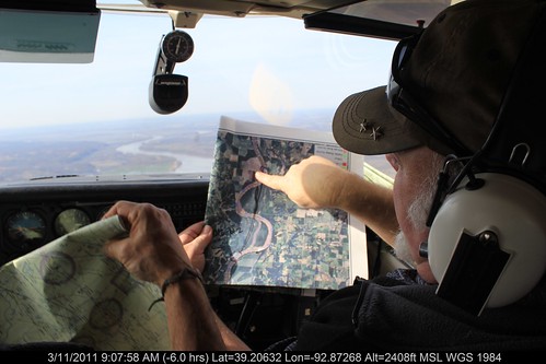
Missouri River Relief hits the skies looking for trash?
On March 11, a couple River Reliefers hit the skies with the Ecoflight crew. Looking for trash.
The great blue sky may seem like a strange place to look for trash, but maybe you haven't seen the massive trash deposits that the Missouri River leaves strewn across its floodplain when it floods.
From the air, you can see plumes of driftwood mixed with plastic barrels & bottles, refrigerators, toys and tires splayed across the floodplain. This is the first step in our Big Muddy Clean Sweep this fall. Figure out where the massive trash piles are, then figure out how to target them from a barge moving down from Kansas City to St. Louis.
Find out more about Missouri River Relief's "Aerial MegaScout" here
And check out the Kansas City NBC press clip here
OR
Check out the KOMU story about the flight.
The Vegetation Communities of the Big Muddy National Fish & Wildlife Refuge
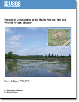
Here's a link to the just released report from the US Geological Survey on the vegetational communities of the Big Muddy National Fish and Wildlife Refuge. http://pubs.usgs.gov/of/2011/1038/
The study covers plots in the Jameson Island, Lisbon Bottoms, Overton Bottoms, St. Aubert's Island and Boone Crossing Units of the refuge along the Missouri River. The report compiles data collected during bird and aerial photography studies in 2002-07 with a more complete vegetation dataset collected in 2009.
The study was completed by Matthew Struckoff, Keith Grabner and Esther Stroh of USGS and published in March, 2011.
Some interesting stuff follows the dynamic changes in young cottonwood and willow forests as they mature following their establishment after the 1993 flood, when many areas of the refuge were taken out of agriculture. As the refuge has grown, some flood protection has been removed allowing for substantial annual flooding. This flooding, in just the past few years, has drastically changed some of the "old field" communities into dynamic and diverse ephemeral wetlands and wet prairies. Cool stuff.
Here's the link to the USGS announcement. From there you can download the report and the detailed appendices.
http://pubs.usgs.gov/of/2011/1038/
Tuesday, March 8, 2011
MRAPs releases Draft Scoping Summary
The Missouri River Authorized Purposes Study run by the US Army Corps of Engineers has released its Draft Scoping Summary. It's a 347 page document distilling the hundreds of public comments received last year during the first phase of the study.
Now MRAPs is moving into a public comment period on the Scoping Summary. Several meetings have been scheduled throughout the basin for public comment.
Click here for more information.
Click here to download the draft Scoping Summary (5.8 MB pdf)
Now MRAPs is moving into a public comment period on the Scoping Summary. Several meetings have been scheduled throughout the basin for public comment.
Click here for more information.
Click here to download the draft Scoping Summary (5.8 MB pdf)
Friday, March 4, 2011
Western ND looks at regional water pipeline
Originally published by Associated Press on March 3, 2011 in the Plains Daily
Original Link click here
BISMARCK, N.D. (AP) -- North Dakota's booming oil industry requires huge amounts of water for drilling, a need the state could use to bring clean drinking water to rural towns, backers of a proposed water pipeline project say.
The Western Area Water Supply project, which the North Dakota Senate's Industry, Business and Labor Committee reviewed Thursday, would pump water from the Missouri River near Williston and sell it to oil companies and cities.
The legislation would set up a board to oversee the project and have the state back the bonds that would finance it. The pipeline network's estimated cost ranges from $150 million to $300 million.
The project's supporters call it an opportunity to build pipelines that will supply drinking water for cities and rural areas, while laying most of the expense onto an oil industry that is ravenous for water.
Skeptics say that if oil prices collapse, the state could be left holding a sizable bill. Water haulers said they have already invested in facilities to serve the industry, which a state-financed pipeline system would undercut.
"We have a great opportunity to build infrastructure to service western North Dakota for the next 100 years," said the bill's sponsor, Rep. Bob Skarphol, R-Tioga. "We have the opportunity to fund it with the help of the private sector's need for water."
North Dakota's oil industry uses a process called hydraulic fracturing to break down underground shale formations to extract oil. A single well can require 1 million to 1.5 million gallons of water during the process.
Companies now often have to haul water by truck, sometimes as far as 40 miles. A pipeline system would reduce hauling time, cut down truck traffic and provide better access to water. Supporters of the project expect oil companies will buy enough water in five to seven years to cover the system's cost.
"It'll benefit the people, and it'll benefit industry by allowing us to buy water," said Ron Ness, the president of the North Dakota Petroleum Council, which represents oil companies working in western North Dakota. "This opportunity only comes so often, when a big commercial user is ready to pay the bill."
The city of Williston and some neighboring water districts have been working on the proposal for more than two years.
Their plan envisions beginning pipeline construction on the Missouri River southwest of Williston and extending in four directions, reaching Grenora to the northwest, Ray to the northeast and Alexander and Watford City to the south.
City officials say Williston has the right to pump up to 30 million gallons of water from the river per day, but it uses only about 3 million gallons.
The city's water treatment plant was renovated in 2006, and can now handle 10 million gallons of water daily. If the Western Water Supply initiative is approved, its treatment capacity could be expanded to 14 million gallons, city officials said.
Opponents say the plan is too risky and could leave the state on the hook for a huge debt. The project's finances depend on oil companies being willing to buy most of the treated water.
"You never, ever can bank on the oil and gas industry," said Michael Nash, who runs a water trucking company in Williston. "We're a transient industry, that's all there is to it. If you bank on this industry, you will get burned. It's not a matter of if, but when."
Owners of private water businesses said the government would be unfairly competing with their industry and could undercut prices. Some said they'd invested hundreds of thousands of dollars in water depots for oil companies, which the pipeline could put out of business.
"If it were not for the entrepreneurs that spent their hard-earned money to respond to the needs of the industry at the time, we wouldn't have the oil industry doing like it is today," said Robert Harms, a lobbyist for independent water companies. "It's because the private sector invested its own money to develop the depots we're talking about."
If the bill is approved, pipeline construction would begin this summer.
The House approved the measure earlier, 91-3. The Senate committee took no action on it after a five-hour hearing Thursday. The panel intends to take testimony from Todd Sando, the state Water Commission's chief engineer, next week.
The bill is HB1206.
Spring Flood Outlook Missouri River Basin
The National Weather Service has released its update of the Spring Flood Outlook maps. Values are not given for the mainstem Lower Missouri River, but gives good information on tributaries. These maps reflect snowpack, soil moisture and existing runoff, but don't take into account precipitation. Some sources are predicting a wet spring so that will definitely affect the Missouri River.
Here's the link to the report, with probability maps
Here's an analysis for North Dakota tributaries.
Here's the text from the NWS report:
THIS SNOWMELT OUTLOOK IS FOR THE MISSOURI RIVER DRAINAGE WHICH
INCLUDES RIVERS IN MONTANA, WYOMING, COLORADO, NORTH DAKOTA, SOUTH
DAKOTA, MINNESOTA, NEBRASKA, KANSAS, IOWA, AND MISSOURI.
Subscribe to:
Posts (Atom)