Wednesday, June 29, 2011

Iowa and Nebraska border becomes an inland sea - flood spreads downstream

It's been said over and over...this flood is unlike any other. Because of the dam system, the Corps of Engineers was able to take the top off a monstrous flood and spread it out over time. So now we have a severe to moderate flood for at least two months straight.

In communities closer to the dam, it's guaranteed to be high all summer. The further downstream you go, the continuous flooding will be less severe, but the chance exists with a lot of rain for a really massive flood event on top of it all. In addition to the tens of thousands of acres of flooded farmland and rural towns behind failed levees, the more protected urban areas are in for a constant test and struggle off their defenses and infrastructure. This is going to be one tiring summer.

A major storm Sunday night focused over Northwest Missouri caused a major spike in areas that had been holding steady because of a lack of rain...from the border south. The rains also caused spikes from Sioux City on down. A heavy equipment operator at the Fort Calhoun nuclear plant near Blair, NE, punctured the AquaDam surrounding the plant, causing floodwaters to move up to the building itself and splashing the plant all over national news. According to plant officials, the building itself is watertight for several more feet. Details in stories below.

It's getting tougher to cross the Missouri River as new bridges are closing each day.
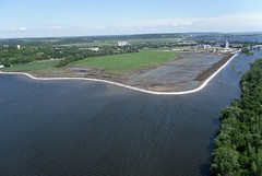
Ditch-6 Levee at Hamburg - June 27, 2011
Hamburg, IA, surrounded by temporary levee
Currently, very little rain is forecast in the basin for the next several days, giving a break for communities preparing for bigger water. Levees are breaking like crazy in northern Missouri/Kansas and heading downstream.

Here's an update on some good news coverage throughout the flood zone:

Some News and Information Aggregate Sites
Big Muddy News only publishes updates a couple times a week. We're a good place to check in here and there for a pulse of what's going on. But there are a lot of constantly updated sites you can check out for the absolute latest information. In addition, browse previous postings for other great links. Here's a few:
Missouri River Flood Event and Activities - interactive map of news, flood relief info and volunteer info:http://mightymoriver.crowdmap.com/
On Facebook:
Army Corps of Engineers Omaha District Flood Page - projections, inundation maps, tips on sandbagging, levee knowledge, more
Army Corps of Engineers Kansas City District Flood Page
National Weather Service Missouri River Basin Overview

Aerial Photos and video

Montana
CNN blog, June 24, 2011 - "Waiting for Snowpack to Melt, How Fast and Furious will the Snowpack Gush into the Missouri River?"  According to the Corps of Engineers, the snow above Fort Peck peaked at 141% of normal and is now down to 25% of normal.  The snow in the reach between Fort Peck and Garrison (primarily the Yellowstone basin) peaked at 136% and is now down to 27%.

Dakotas
KSFY-TV - Pierre - "Local official tried to warn Corps of potential flooding in February" - a story about a local man who had been watching snowpack accumulate in National Weather Service data and tried to spread awareness of the possibility of major flooding. This was before the May rains that changed the game. A well done, non-hysterical local news story.
US Army Corps of Engineers - June 28, 2011 - Corps to inspect spillway gates at Big Bend July 1 - The Corps will be shutting down the spillway to check for erosion and stability of structure. They anticipate this will take one day. 
Bismarck Tribune - June 28, 2011 - "Missouri River Scour threatens property, digs deep"  Scouring has created spots along Missouri River 100 feet deep.

Iowa/Nebraska
Omaha World Herald, June 27, 2011 - "Flood test not over for nuke plant"
Omaha World Herald, June 27, 2011 - "NRC chief stays dry at Cooper plant"
Omaha World Herald, June 28, 2011 - "NRC: Nuke disaster risk low" after visiting Fort Calhoun plant
Omaha World Herald, June 29, 2011 - "Bridge stroll a lesson on the river" Teachers use the flood as a teaching tool.
KETC-Channel 7 - Omaha, June 28, 2011 - "Bluffs residents fight flood from below - Water reported in hundreds of basements in city"
Sioux City Journal, June 28, 2011 - "All's quiet in Decatur with bridge closed"
Reuters, June 27, 2011 - "Regulator signs off on threatened Cooper nuclear plant"
Associated Press, June 27, 2011 (video) - "Flood Challenges nuclear plant"

Missouri/Kansas
St. Joseph News-Press, June 27, 2011 - "Flooding Closes Casino"
St. Joseph News-Press, June 28, 2011 - "Officials fight flooding river" Including photos of casino employees cars flooded in parking lot.
St. Joseph News-Press, June 28, 2011 - "As flood closes highway bridge, Atchison residents worry" Atchison, KS, cut off from Missouri.
Kansas City Star, June 27, 2011 - "Information on Flood flows many ways" - Social media helps spread important information along with misinformation.
Kansas City Star, June 28, 2011 - "Businesses get ready for Missouri River flooding"
Columbia Missourian, June 29, 2011 - "Missouri River Flooding Closes one road to Cooper's Landing" Actually both roads are covered right now. Waters should begin dropping this weekend. 
Lake News Online, June 28, 2011 - "Flooding on Missouri Slows down Bagnell Dam operations"
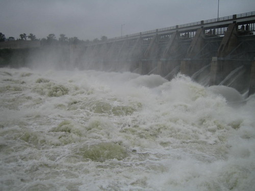
Sunday, June 26, 2011

160,000 cfs to continue until mid-August

Once again, substantial rain in the upper basin, as well as the lower river, forced the Corps to bump up their Gavin Point dam releases to 160,000 cubic feet per second (cfs). They now say this new peak flow will continue "well into August". Revisions of the projected flood inundation maps will be released soon. Releases are being adjusted constantly throughout the reservoir system as the Corps tries to make room for new pulses of runoff while providing a steady flow out of Gavin's Point Dam.

Many more levees have broken and overtopped, floodwaters are backing up into new areas and up the tributaries. Several more towns have been evacuated. With rain on top of that, the hydrological projections have been gyrating and changing with each new projection. That uncertainty on top of the certainty that this will go on all summer is a tough combination for everyone that lives or works along the river.

It appeared earlier this week that levee breaches dropped the "crest" enough at Brownville to keep the beseiged Cooper Nuclear Plant from reaching their "mandatory shutdown" river stage of 45.5 feet. Yet after a brief trough, the projection goes up again. Towns in the St. Joseph area experienced the same reprieve.

The Iowa & Nebraska border has become an inland sea pinched off by an hourglass bottleneck at Omaha/Council Bluffs. An inland sea moving downstream but not going away anytime soon.

Dramatic images of Nebraska's two nuclear power plants surrounded by water have helped fuel some wild rumors. There is a section below of stories related to these plants. 

One by one, communities downriver are adding flood protection, or moving out. The uncertainty of what will happen is forcing decisions to take action now. All river traffic has been closed by the Coast Guard from Leavenworth to Gavin's Point Dam.

The tenacity and hard work of family, neighbors and volunteers has been a major part of the story in this midwest region. There is a lot of frustration, of course, and the blame game is ongoing, but mostly people realize the reality of the situation and are acting on their own to deal with it. It's pretty inspiring, and what some of these communities have accomplished in short times is amazing.

A lot is being published on the web on the flood, despite the relative silence in much of the national media. There are several great news feeds, both from official sources and the general public. I've posted many of these in previous posts. Here's a collection of stories and links from the past several days:

Interactive Flood Maps
link to news stories, volunteer info and more
Missouri River Flood & Event Activities - a volunteer-based information "Crowdmap" network on the flood
Interactive Flood Map - Omaha World-Herald updates each day: shows county by county updates of Iowa/Nebraska flooding
Advanced Hydrological Predictions - Missouri River Basin - click the colored dot to link to hydrograph. 
Montana
Great Falls Tribune, June 24, 2011 - "Flooding Likely to Return to Montana"
Story from June 6, 2011 - for perspective on the snowmelt we are now experiencing - Bismarck Tribune - "Abominable Snowpack Lurking in Montana Mountains"

Dakotas
Pierre Capital Journal, June 24, 2011 - "High Tributary Flows Due to Heavy Rain Near Pierre"
Associated Press, June 24, 2011 - "SD Gov. Dennis Daugaard takes lead role in Missouri River flood fight"
Yankton Press-Dakotan, June 24, 2011 - "Flows Of 160,000 cfs Threaten More Yankton-Area Homes"
Yankton Press-Dakotan, June 25, 2011 - "Residents rush to fix levees"
Bismarck Tribune, June 25, 2011 - "Groups begin planning for flood aftermath of tree die-offs"
Bismarck Tribune, June 24, 2011 - "Voluntary Evacuations to continue indefinitely"
Pierre Capital Journal, June 25, 2011 - "Oahe Reservoir to peak 2/10 of a foot from top of spillway gates"

Iowa/Nebraska
The Omaha World Herald has run a really good series of background articles following up recent days rain -
Reuters, June 24, 2011 - "Above the Missouri River, only treetops and rooftops" 
Council Bluffs Daily Nonpariel, June 25, 2011 - "FLOOD: Farmers, officials join forces to fortify levees, keep water at bay"  - volunteers and officials rebuild over 30 miles of levees in area north of Council Bluffs.
Lincon Journal-Star, June 24, 2011 - "It's season of flooding, finger-pointing for Corps of Engineers"
Wallace's Farmer, June 24, 2011 - "Flooded Farmers reassured by USDA Risk Management Agency" - Flood insurance will apply to this event for farmers. The other side of the coin is the many people who never anticipated a flood, weren't in a federal floodplain but are flooded.
Sioux City Journal, June 25, 2011 - "Truckers driving more to accommodate I-29 flooding detours''
Sioux City Journal, June 26, 2011 - "EXPLAINER: How Americans came to rely on the sandbag"
PHOTOS - Sioux City Journal, June 23, 2011 - Flooding in South Sioux City
Des Moines Register, June 26, 2011 - "Opinion - Missouri River Compromise"

Updates on Cooper and Fort Calhoun Nuclear Plants
Iowa Independant, June 24, 2011 - "NRC spokesman: No need for Nebraska spent nuclear fuel casks to be protected"
Associated Press, June 24, 2011 - "Nebraska nuclear plant gets relief from levee breach"

Wall St. Journal, June 24, 2011 - "Nuclear Regulator to visit Nebraska Plants Amid Flooding"
Bulletin of Atomic Scientists - "Rising Water, Falling Journalism"
US Nuclear Regulatory Commission Public Relations - "Rumors and the Rising River"
Ashville Citizen-Times, June, 24, 2011 - "Floods spur wild rumors of nuclear plant perils in Nebraska"

Kansas/Missouri
St. Joseph Channel 3 - June 24, 2011 - "Atchison County Residents Worn Out by Floodwater" with video
St. Joseph News-Press - June 25, 2011 - "Nasty Stuff - Public Advised to Stay Away from Floodwaters"
St. Jopeph News-Press - June 25, 2011 - "Trying to make a living - Businesses affected by flood find day-to-day operations difficult" - A 27 mile commute becomes a 150 mile commute with road closures.
Kansas City Star, June 24, 2011 - "Levee break upstream delays flooding near Kansas City" & "Corps letter causes dust-up"
Kansas City Star, June 25, 2011 - "Levee breaches continue"
Columbia Missourian, June 24, 2011 - "Flood barriers placed along Katy Trail in Rocheport" It's a precaution. This river town is still open for business and Katy Trail is open. 
Kansas City Star, June 26, 2011 - "Missouri River is taking toll on recreation" 

Tuesday, June 21, 2011

Some dams increase to 160,000cfs; more levees fail in Iowa and Missouri

Rain (and predicted rain) in the upper plains states have caused the Corps of Engineers to ramp up releases of water from Oahe and Big Bend reservoirs to 160,000 cfs. In their nightly briefing, the Corps said, "If weather continues to deteriorate the Corps will lose its ability to manage intra-system adjustments and may have to increase releases from Fort Randall and Gavins Point".The releases combined with rain have increased flooding in the Pierre, SD area. Rainfall also has caused small spikes in the river in the Sioux City area and below.

The Corps releases daily average inflow and outflow at each dam, and on Monday, June 20, 4 out of the 6 dams in the system were receiving much more water than they were releasing.

Over the weekend, several levees breached or began overtopping near the Iowa/Missouri border, flooding areas near Big Lake, Craig and Rockport, MO, and Brownville, NE. The Coast Guard closed an additional 100 miles of the river to all navigation. The river is now closed from St. Joseph (rivermile 450) to Gavin's Point Dam (rivermile 811).

Sandbagging has been ongoing along the Nebraska/Iowa border, and sand supplies are getting low in Omaha and Sioux City. Infrastructure continues to be strained, with sewer and drainage problems increasing as many outflows to the river are closed. 30% of Nebraska's power production is offline due to flooding. Huge swaths of agricultural land are flooded in Nebraska, Iowa and northern Missouri. All bridges crossing the river south of Plattsmouth and north of St. Joseph are closed due to flooding on their entrance ramps. Many highway and road closures, including sections of I-29, are causing major travel delays across the region.

Wednesday, June 15, 2011

150,000 cfs - the long flood fight has just begun

On Tuesday, June 14th, the Corps of Engineers brought releases at Gavin's Point dam up to 150,000 cfs. Releases are expected to stay there until at least mid-August, according to the latest Corps announcements. Rain continues to fall in the upper basin, and rain storms (not extreme) have been moving through the lower basin all week, expected to continue through to the weekend.

Levees and banks, expecially temporary sandbag and earthen levees are now being tested, and will continue to be tested as the summer onslaught continues. Levees have been breached near Hamburg, IA, and in Holt County, MO. Throughout the areas receiving the most intense flooding, the Dakotas, Nebraska and Iowa, it is agricultural land and rural communities that are the most hard hit. Urban areas are generally more protected, but are feeling the effects of road and interstate closures, utility infrastructure flooding, tributary flooding and bank erosion. The aerial photos being posted on the web (some linked below) are stunning.

The further downstream in Missouri you go, the less intense the threat is. Rainfall in tributaries such as the Grand has been less intense than the past several years, giving a cushion to downstream areas. It appears that a baseline for mid-Missouri, for example, is coming in below the Corps estimates. At least for the moment. Large snowmelt is expected in the Platte valley and new releases are being let out of Kansas River basin reservoirs ahead of the major water on the Missouri, and to release pressure on reservoirs such as the Milford Dam. The Corps continues to draw down Truman Lake on the Osage.

Here's some links to check out the latest on flooding:

Facebook 
There are several really good Facebook pages focused on the flood, posting news stories from around the basin as well as information on sandbagging, relief efforts and Corps press releases. Here's a few I've been looking at:
Aerial Photography
Corps Response
Brigadier General McMahon explains how Master Manual guided decisions during winter and spring. Click here.

Montana
Great Falls Tribune, June 13, 2011 - "Fort Peck officials work to stay ahead"

Dakotas
Bismarck Tribune, June 13, 2011 - "Flood Pollution will be minimal, experts say" - the article suggests the large flows should dilute toxins, then describes all of the things that are bound to end up in the river.

Video of canoe trip through flooded Bismarck - Say Anything Blog - June 14, 2011 - Click here.


Sioux Falls Argus Leader - "Residents deal with high water" - touching video of interviews with Dakotans fighting the flood.


Nebraska-Iowa
Hamburg Reporter, June 15, 2011 - "Update: Breach grows; new estimates indicates temporary levee near Hamburg may be topped"


KETV Channel 7, Omaha, constantly updated - Gallery of viewer submitted photos


Sioux City Journal, June 15, 2011 - aerial video tour of Siouxland area 

Keloland TV, June 15, 2011 - "Big Sioux Floods Missouri River Boat Club"
Keloland TV, June 15, 2011 - "Missouri eating away at small river community"

Iowa Public Radio, June 15, 2011 - "Engineer doubts temporary levees will hold back floodwater"

Omaha World-Herald, continuously updated - "County by County map and flood impact updates" - a great at-a-glance resource. 
Omaha World-Herald, June 15, 2011 - "Eppley fights off floodwaters" - the Omaha airport tries to keep floodwaters out.
Omaha World-Herald, June 15, 2011 - "Heineman's worry: Will Levees Hold?"
Omaha World-Herald, June 11, 2011 - "Policyholders get late surprise"

Des Moines Register, June 10, 2011 - "Branstead Chides Corps Missouri River management"

Videos of Hamburg Levee Breach posted by Atchison County Emergency Management. Click here.

Missouri
Kansas City Star, June 12, 2011 - "All hands on deck in St. Joseph" -

St. Joseph News-Press, June 8, 2011 - "Power Plants Prepare for Flooding"


Marshall Democrat-News, June 14, 2011 - "Expected flood of 2011 may be less dramatic, more chronic than 1993"


KRCG 13 TV, June 14, 2011 - "Mid-Missouri officials prepare for Missouri River flooding"

St. Louis Post Dispatch, June 15, 2011 - "Senator Blunt blames Missouri River flooding on 'faulty plan'" and then proceeds to spread more misinformation blaming endangered species. Unbelievably, he claims the Corps was holding water for their "Spring Rise" plan. Hopefully as this event proceeds, our policy makers will eventually be educated on the reality of the Missouri River.
St. Louis Post Dispatch, June 13, 2011 - "Army Corps of Engineers defends handling of Missouri River"
St. Louis Post Dispatch, June15, 2011 - "Flooding not expected to be heavy in St. Louis area, Corps says"

Friday, June 10, 2011

Gavin's releases approach 140 kcfs, new levees being tested

 As flows from Gavin's Point Dam approach 140 kcfs (thousand cubic feet per second), new levees and sandbag structures are being tested throughout South Dakota, Iowa and Nebraska. In addition to flooding of riverside homes and businesses, utilities and infrastructure are being tested in many communities. From water supplies, wastewater plants and train routes to interstate closures and electric plants, eyes are watching the rising floodwaters and the effects it will have on commerce and basic services. See below for frightening video of the Fort Calhoun Nuclear Plant, which is already surrounded by water.


Lower on the river, Missouri communities are attempting to prepare for predicted high flows which, because of relatively dry weather and low flowing tributaries, have not yet manifested. Rain is currently falling in Nebraska, Iowa and northwestern Missouri, heightening the chances for increased tributary flow.


Missouri River Flooding 2011 Facebook page
This page is doing a good job posting news stories several times a day from communities struggling with flooding. Click here.

Monday, June 6, 2011

Dam releases spike over weekend

Following their plan of evacuating high runoff through the Missouri River reservoir system, the Corps of Engineers began accellerating releases from a string of mainstem dams this weekend. In order to give communities time to react to the impending flooding, the Corps had slowed the increase in releases last week. Late last week, those releases began to accelerate again.

Rain continues to fall in the upper basin, but the Corps has not publicly changed their reservoir operation schedule at this time. A spat of dry weather in the lower basin has given a moment of relief for lower river communities preparing for a summer of high water.

As the stakes have risen, various theories of blame have been tossed around, from blaming the Corps of Engineers for not releasing enough water this winter to blaming "upstream states" for fighting to hold too much water in the reservoirs for recreation to blaming the Endangered Species Act for somehow tying the Corps' hands. None of these scenarios is really true. The Corps followed their Master Manual, designed to leave plenty of room in the reservoirs to handle snowmelt and runoff. The runoff this year is unprecedented in timing and scale. The endangered species on the river had no impact on the Corps release decisions.

Missouri River 340 cancelled - moved to Kansas River

Organizers of the Missouri River 340, the world's longest non-stop paddler race from Kansas City, KS, to St. Charles, MO, have elected to cancel the ultramarathon race for 2011 due to a high likelihood the race course will be flooding at the scheduled date.

The race had registered over 340 boats for the 2011 event, which was to be the sixth annual run of the race. Near certainty of above flood stage river levels for most of the race course caused race organizer Scott Mansker to look for a new alternative. In order to give an option for racers who have been planning for months on the original July 19-22 dates, Mansker's organization, Rivermiles, elected to move the race to an alternative location, 150 miles of the Kansas River, from Manhattan, KS, to Kansas City, KS.

Friday, June 3, 2011

Editorial: Flood blog by author of "Unruly River"

For folks trying to understand the history and changes of the Missouri River, you can't do much better than reading "Unruly River" by Robert Kelley Schneiders.

Right now Dr. Schneiders is in the Dakotas now and is travelling along reporting on the flood as it happens throughout the basin. You can follow his observations at: http://ecointheknow.com/news/  .

Here's one of his pieces published June 3, 2011 in the Omaha World-Herald, reprinted with the author's permission. As always, the opinion pieces reprinted on Big Muddy News reflect the opinions of the author alone. They are important for gaining perspective on a complex issue.

Midlands Voices: Rethink flood role of Corps

By Robert Kelley Schneiders, Ph.D.

The writer, of Boulder, Colo., has written two books on the history of the Missouri River, “Unruly River: Two Centuries of Change Along the Missouri” (University Press of Kansas, 1999) and “Big Sky Rivers: The Yellowstone and Upper Missouri” (University Press of Kansas, 2003). He is the co-founder and director of Eco InTheKnow, LLC, www.ecointheknow.com.

Thursday, June 2, 2011

Flood Update - Stories throughout the basin

As the flood moves through the reservoirs in Montana and the Dakotas, unprecedented flooding is occurring in communities adjacent to the river below the dams. Rain continues to fall in Montana and snow melt has certainly begun in earnest, flowing into already swollen tributaries that feed the dams.

Several of the dams have reached capacity, and now Garrison Dam, above Bismark/Mandan North Dakota has begun opening it's spillway gates. This is part of the emergency plan the Corps has in place, but is the first time this has happened. Pierre, SD below Oahe Reservoir is being hit very hard, with emergency levees being built and preparing for over a month of very high releases.

In the lower river, below the Gavin's Point Dam, upstream communities are seeing rising waters in direct correlation with the increasing dam releases (now releasing at 85,000cfs) . Those releases will be increasing fast over the weekend and into next week, reaching 140,000 cfs by early next week (a bit earlier than previously projected). 

The Corps has released flood inundation maps for the Omaha District (the Dakotas south to Rulo, NE). You can view them and other helpful documents on the US. Army Corps of Engineers Omaha District Flood Response Page by clicking here. The Kansas City District has provided a range of river stages to be expected from Rulo, NE to Hermann, MO throughout June and July, as the dams are releasing 150,000. You can access those on the Kansas City District Flood Response Page by clicking here. They also have offered a document showing at what level each levee will be overtopped and how likely that is (click here for levee projections)

Just how bad this will get is uncertain everywhere...the rapidity of snowmelt and precipitation can change everything. But the further downstream you go the more uncertain it gets, with the addition of tributaries like the Platte, Kansas, Grand, Osage and Gasconade. If there is significant rain, even similar to the last several years, we are looking at levels we haven't seen since 1995.

Here's a few stories from throughout the basin:

Montana
Associated Press, May 30, 2011 - "More rain, snow, National Guard troops for Mont."
Towns in Montana and the Dakotas struggle with flooding, prepare for more.

North and South Dakota
Huffington Post, May 31, 2011 - "Missouri River Flooding 2011: South Dakota Residents Told Evacuation Could Last 2 Months (with video)"
Towns are sandbagging and evacuating communities predicted to flood for several months.

U.S. Army Corps of Engineers Release, May 31, 2011 - "Garrison Dam spillway gates to open for floodwaters for first time"

Cherokee Chronicle Times, May 31, 2011 - "South Dakota towns erect flood walls"

Nebraska
Lincoln Journal Star, May 31, 2011 - "Diminsions of river overflows getting deeper"
Reservoirs in in the Platte are being drawn down as soon as possible ahead of snowmelt and ahead of highest Missouri River flows. Eyes are on the Cooper Nuclear Plant near Brownville, NE, where the access road from Brownville is flooded and 6.5 more feet of water would force a plant shutdown.

Video: from Omaha World Herald Tribune of flooding in many NE and IA communities, June 2, 2011 - "Flooding Sights and Sounds"

Iowa
Sioux City Journal, June 1, 2011 - "Plan for South Sioux City flood barrier takes shape"
& "Flood of 2011 one for the history books"


Omaha World-Herald, June 2, 2011 - "Southwest Iowans pack up"

Missouri
St. Joseph News Press, June 1, 2011 - "Army Corps predicts river at 27 to 32 feet in St. Joseph"

Columbia Missourian, June 1, 2011 - "Record Precipitation, Reservoir Releases to Cause Missouri River Flooding"
A great overview of the flood from the perspective of Mid-Missouri.

KMOX - ABC News St. Louis, June 2, 2011 - "NWS: Dire Warning About “Significant Flooding” Threat Along Missouri River"


Wednesday, June 1, 2011

Some 2011 Flood Resources

Just wanted to get a few links out there, where you can find more information relevant to your location along the Missouri River. Many of the prediction products will be updated, so check back in to the District Flood pages to find updates.

U.S. Army Corps of Engineers, Omaha District Flood Resource Page - they handle the reservoir releases and the Missouri River from North Dakota to Rulo, NE - http://www.nwo.usace.army.mil/html/op-e/flood.html


U.S. Army Corps of Engineers, Kansas City District Flood Resource Page - they handle the Missouri River from Rulo, NE, to Hermann, MO - http://www.nwk.usace.army.mil/Flood/index.cfm
National Weather Service Advanced Hydrological Prediction: http://water.weather.gov//ahps2/glance.php?wfo=eax&gage=kcdm7&riverid=203276&view=1,1,1,1,1,1
Check the boxes of the river gages you want to view on the left, click the info you want to view on the right, then click "Make my River Page" on the bottom. This only takes into account 24 hours advanced precipitation, but will have the reservoir releases built in to its prediction.